The northern Gulf of Mexico has been a ho-hum-ish place this summer but it's still very early in the season and things are bound to start getting more interesting. The activity has primarily involved Florida up through South Carolina.
T.S. Ernesto, heading through the eastern Caribbean initially looked promising for a situation that would affect my area personally (S. MS) but has taken a southern turn and will probably affect the Yucatan peninsula instead. Of course, model predictions are only as good as the information they're fed and are not infallible in any case, so we'll just keep an eye on it. Even if it restricts itself to the southernmost parts of the Gulf it will affect the surf in the rest of the Gulf so people living on the coast will notice a difference.
T.S. Florence is way out there in the eastern Atlantic but is a more organized storm than Ernesto at the moment. It looks like it probably won't even make it into the Gulf but head up the Eastern Seaboard instead. so will be slightly less interesting from my personal point of view.
A brief look at the summer season so far (since I've been such a lazy bum):
T.S. Alberto: [May 19-22] Formed off the SE coast of TX and stayed offshore. 23rd pre-June named Atlantic Basin storm on record since 1851. Other than some rain, little impact on land.
T.S. Beryl: [May 25-30] Ruined Memorial Day weekend for many on the SE US coast. Wandered around before finally making landfall as the strongest tropical storm to hit the US mainland before June 1st. Several inches of rain, wind and downed trees (and powerlines) were the result of its march through Georgia and South Carolina before it surrendered.
Hurricane Chris: [June 19-22] (from the Weather Channel:) "While Chris was no threat to land, it became the 2012 Atlantic season's first hurricane on June 21, at a latitude of roughly 41 degrees north, no less! Only one other time on record during the month of June was an Atlantic hurricane farther north than Chris. You'd have to go all the way back to 1893, when a hurricane in post-analysis made it as far as 44 degrees north latitude, just south of the coast of Newfoundland! Only twice before in history (1887 and 1959) has the third storm of the season formed earlier than Chris." Chris never impacted land but made a semi-circle in the North Atlantic.
T.S. Debby: [June 23-27] The average date for the formation of the season's 4th named storm is August 23rd. Note that we're already on our sixth named storm and it's only August 5th! Debbie was primarily a rain event which sounds rather boring until you realize that it was a LOT of rain. Look at the NASA map below to see some of the cumulative rainfall amounts. The most was an unofficial report of 28 inches in Wakulla County, FL.
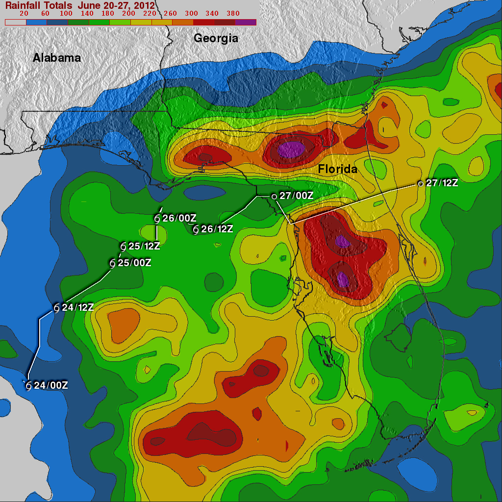
There were also 21 tornadoes associated with Debby, with one fatality reported from an EF2.
T.S. Ernesto, heading through the eastern Caribbean initially looked promising for a situation that would affect my area personally (S. MS) but has taken a southern turn and will probably affect the Yucatan peninsula instead. Of course, model predictions are only as good as the information they're fed and are not infallible in any case, so we'll just keep an eye on it. Even if it restricts itself to the southernmost parts of the Gulf it will affect the surf in the rest of the Gulf so people living on the coast will notice a difference.
T.S. Florence is way out there in the eastern Atlantic but is a more organized storm than Ernesto at the moment. It looks like it probably won't even make it into the Gulf but head up the Eastern Seaboard instead. so will be slightly less interesting from my personal point of view.
A brief look at the summer season so far (since I've been such a lazy bum):
T.S. Alberto: [May 19-22] Formed off the SE coast of TX and stayed offshore. 23rd pre-June named Atlantic Basin storm on record since 1851. Other than some rain, little impact on land.
T.S. Beryl: [May 25-30] Ruined Memorial Day weekend for many on the SE US coast. Wandered around before finally making landfall as the strongest tropical storm to hit the US mainland before June 1st. Several inches of rain, wind and downed trees (and powerlines) were the result of its march through Georgia and South Carolina before it surrendered.
Hurricane Chris: [June 19-22] (from the Weather Channel:) "While Chris was no threat to land, it became the 2012 Atlantic season's first hurricane on June 21, at a latitude of roughly 41 degrees north, no less! Only one other time on record during the month of June was an Atlantic hurricane farther north than Chris. You'd have to go all the way back to 1893, when a hurricane in post-analysis made it as far as 44 degrees north latitude, just south of the coast of Newfoundland! Only twice before in history (1887 and 1959) has the third storm of the season formed earlier than Chris." Chris never impacted land but made a semi-circle in the North Atlantic.
T.S. Debby: [June 23-27] The average date for the formation of the season's 4th named storm is August 23rd. Note that we're already on our sixth named storm and it's only August 5th! Debbie was primarily a rain event which sounds rather boring until you realize that it was a LOT of rain. Look at the NASA map below to see some of the cumulative rainfall amounts. The most was an unofficial report of 28 inches in Wakulla County, FL.
There were also 21 tornadoes associated with Debby, with one fatality reported from an EF2.
No comments:
Post a Comment