But a storm by any other name would be as destructive.
A long time ago (but not in a galaxy far, far away), someone came up with the idea for naming tropical cyclones. The credit is given variously to several people but it doesn't really matter now. The point is it turned out to be a pretty good idea.
A lot of work and collaboration has gone into the strength rating and naming of storms over the years and slowly it has become a quite well-oiled machine. No one really has any problem with it. The only little hitches were when people (feminists) decided to become offended because all the storms had female names. To me this was only a natural outgrowth of other naming systems: boats and ships were traditionally given female names (and mostly still are) and a lot of times fighter pilots in the wars unofficially named their planes after wives or sweethearts. So it changed to alternating male and female and the dust settled until the next beleaguered group reared its head. Now we have both male and female names of English, French and Spanish origins in the Atlantic and of multiple other (including Polynesian, Japanese, etc.) origins in the Pacific. This makes sense for the areas the respective storms will affect.
The Saffir-Simpson hurricane scale was created in 1973 and went through various adjustments over the years, the latest adjustment being only this year. Thus we have a relatively simple system for telling how strong a hurricane or typhoon is and a way to quickly and easily identify it in all of the countries which it may affect.
All well and good. Then an entirely new animal emerged just a little while ago: the naming of winter storm systems.
The excuses given are various but THE claim to credibility is the precedent set by the Europeans to name winter storms. Let's just look at that for a moment:
First, the Europeans name all major windstorms, not just winter storms (although most do occur in the winter). Second, a given windstorm will likely track across multiple countries in the course of only a few days and it is not a bad idea to have one name for the thing so there isn't confusion. Third, given number two, you would think that you would thereby avoid confusion by having an official naming system. Alas, no. The media started the naming system and it gradually spread. Because it is not sanctioned by any international meteorological society the storm can acquire different names along its course. Fourth, you can have multiple winter windstorms affecting Europe at one time so naming them is a way to distinguish between them.
So, back to this interesting development in the U.S. The Weather Channel unilaterally created and instituted this naming system. The Weather Channel, contrary to what some people think, is not an official and disinterested meteorological body. [The National Weather Service (NWS), one branch of the National Oceanographic and Atmospheric Administration (NOAA) is an official government body.] TWC exists to make money, plain and simple. It is not a non-profit. It is interested in increasing ratings and thereby increase income. Everyone knows how hyped up hurricane season has become an how people hang on TWC's every word. When there is a storm about you can go into restaurants with bars and the televisions are tuned in to the TWC. It's playing in the airports. It's everywhere. I admit that when we had cable (almost 3 years without!) I would watch it too...although not 24 hours a day. All it does is keep recycling the same thing every 15 minutes. When hurricane season is over things settle down. The excitement goes down. You don't go into public places and look up to see people in yellow slickers with "TWC" emblazoned across the front hanging onto lamp posts with the wind blowing them at 45 degree angles. Consequently, ratings must go down.
By deciding to create the same excitement during the winter as during hurricane season, you never get that drop in ratings. About the time the last hurricane has blown through there's snow on the back side of it. [Spring is already covered with "Tornado Season".] It's brilliant.
Do we need it? I have to say, by the time we're seeing the end of hurricane season (and usually well before) I'm a bit sick of the hype. I don't mean the well-deserved warnings and the sober predictions, I mean the hype. Winter is a relief from all of that. And now we're not even to get that break? It's like always being in election year. Gah!
So, back to the question, do we need it? I say no:
1. When a winter storm system comes through the U.S., it generally affects Canada and the U.S., two quite large countries. It's not hard to communicate storm warnings between only two countries.
2. We usually don't have two major winter systems at once although we have had up to several tropical systems being tracked at the same time.
3. Naming winter storms is a good way to confuse tropical and arctic systems as far as the public is concerned. Someone will say, "Remember Olive?" and the other person is left wondering if it brought blizzards or beach erosion. This does bring up the point: how are we going to have naming systems that are obviously distinguished from one another?? Is there something about "Alvin" that is tropical and "Marvin" that is wintry?
I would rather see the NWS institute a winter storm naming system if it is going to be established. I would still have arguments against it but at least I would feel that it was a fairly unbiased decision. As it is, TWC seems to be coming up with the latest gimmick to line its pockets.
At least one weather station's reaction to all the hype:
84 years ago last night, September 16th-17th, 1928, a hurricane made landfall in south Florida. The eye made landfall near West Palm Beach and then moved right over Lake Okeechobee.
Thousands of migrant farm workers, mostly black, lived in the low areas near Lake Okeechobee. There was a 5 foot dike to keep the waves out during storms, but it was no match for the hurricane. The figure below details the area that completely flooded. The southern end flooded first; when the eye passed over the northern end that area flooded as well.
People living in the area had evacuated initially but the hurricane did not show up when predicted. They went home, a fatal mistake. Thousands perished, many bodies being washed into the Everglades where they were never found.
(click to enlarge)
The racism of the day dictated what happened next. The few coffins were given to bury white victims; the black victims were either burned or dumped in mass graves with no memorial markers. It was only in the last several years that markers were put up.
The Red Cross initially estimated the dead at 1,836 but because so many bodies were never found and the migrant population was not well documented, that number was probably much higher. In 2003 the death toll was revised to "at least" 2,500 to reflect that. This makes the 1928 Lake Okeechobee Hurricane the second-deadliest to make landfall in the U.S. (the greatest being the Galveston Hurricane of 1900 with a death toll of 8,000 - 12,000).
[1963] U.S. Meteorologist Robert L. Smith checks over one of the radar operated
weather tracking pieces of equipment in the U.S. Weather Bureau located
in this northwest Florida coastal city [Apalachicola, FL]. This station is one of five
that fringe the state. The equipment Mr. Smith is looking at is a radar
operated camera that takes both still and movies of heavy weather
disturbances up to 150 miles away. The picture at the right was made
several years ago and shows a hurricane off the southeastern Atlantic
coast.
The first Doppler-radar measurements of a tornado were made in 1958 by U.S. Weather Bureau meteorologists R. Smith and D. Holmes. They obtained a Doppler radar from the U.S. Navy, set it up in Wichita, Kansas, and then waited. Just over a year later, on June 10, the radar detected a tornado in El Dorado twenty-five miles away. What luck that a tornado happened to touch down within range of the first Doppler radar used for meteorological purposes! The likelihood of a tornado striking within thirty miles of a given location during a given spring is extremely small. Although at the time it was not possible to discriminate between approaching and receding velocities, the wind spectra obtained by this radar detected maximum velocities (that is, wind speeds in the line-of-sight direction) of 200 mph.
-Tornado Alley: Monster Storms of the Great Plains, 1999, Howard B. Bluestein, p. 12-13
Just a quick post to note that it is almost 9 AM and 65 degrees with 77% humidity outside! It's going to warm up, of course, but we should not have a heat index over 100 and we should also get some breeze today. Thank God! I know that summer is not over, by any stretch of the imagination, but it's SO nice to get a break.
Right now the temperature is 97.9 with a heat index of 113. Ok, that's too hot. Just. Too. Hot. This morning I woke up, looked out at a nice, fresh-looking day with a breeze, and sitting in an air-conditioned house thought, "My, what a lovely fall day it looks!" On examination, the temperature was already over 80 and the air was soggy.
Enough already!!
It looks as if there's supposed to be a cold cool front coming in on Saturday and from Sunday on (at least as far as the forecast goes) the temperature should be much more moderate: highs from 75 to 81 and lows from 59 to the mid 60's. There's also supposed to be a breeze with that, mostly out of the north.
We seem to be among the very lucky people because we only lost power for a few hours last night, still have power, water and internet...and an intact roof. The other side of our street doesn't have power and indeed, most of our town doesn't have power. In fact, I can hear the generator running at the ATT building on the opposite corner of our block. Our house is fine; we mostly have small debris covering everything. The church and hall are fine except for the same small debris. I went out to see what was going on (which you're not supposed to do) and took some pictures. I did pass one house partly smashed by a large tree, but I didn't take a picture; it seemed heartless.
This is at the end of our street, a block and a house away.
Looking through the blocked intersection.
Another view. You can see it came down right across the power lines.
Three blocks from our house.
About ten blocks from our house.
About five blocks away on the main road. The signals are out.
And in one case...missing.
About eight blocks from our house in another direction.
About four blocks away.
And, a little closer to home, the zinnias survived.
And we wound up with just a light covering of small debris.
Interestingly, I found this graphic:
Our little town has achieved notoriety. Also, it explains why the dam at Percy Quin State Park is full and about to go. They are evacuating 50,000 people below the dam in Tangipahoa Parish, LA. Let's hope it holds.
It's neat to look at our local stats for the week and see Isaac pass. Of note: The humidity was very high (duh!) so you see the temperature and dewpoint right up next to each other. Notice that the temperature remained fairly constant once the heavy cloud cover and rain started. Looking at the pressure you can see that just after midnight the center of the storm passed. Even though I don't exactly remember it, apparently we had gusts to just over 40 mph but our steady winds never really got out of the 20's. MUCH lower than forecasted. Also interesting, you can see the wind direction changing from the north to the east and now to the south as the storm passed by.
Frankly it has been a rather boring day. It has rained, more or less continuously, and we've officially had just under 2 1/2 inches of rain. The wind started out just a bit squally but graaaaadually increased to gusts of 20-30 mph. We haven't lost power and the weather has generally not lived up to the forecast, but then it rarely does. Isaac, now back to a tropical storm, is nowhere near gone though: It was moving at about 7 mph this morning and now it's moving about 5 mph to the NW. We've got a loooong way to go. In fact, Pickles remarked on how long the storm was lasting while I was out on the porch taking a video of the winds. As usual, a child steals the show.
I woke up this morning to squally conditions but nothing impressive. Isaac is still moseying along at 6 mph. It's basically going to keep raining for the next 24 hours or so.
The cat, who is well on his way to being named Isaac, is still with us. He's chasing a moth in the window of the porch as I type. I think he spent the night under the house.
I'll update as soon as there's anything worth updating. Ho hum.
Well, it's about time! I missed the advisory 30 minutes ago (wasn't expecting it and you have to clean the kitchen sometime) so my sister had the joy of texting me to tell me that Isaac had finally attained hurricane status.
It's gotten rather pretty too... (But notice the blurb at the top left still says "tropical storm")
Tuesday afternoon (28th): The last update showed steady winds of 80 mph with gusts to 95 mph so there is some slow strengthening going on. I'm not sure how much stronger it will get before interaction with the coast starts bleeding out the energy. We've had one rain band go through, not much more impressive than a garden-variety rain shower. At the moment the sky is streaked with clouds with plenty of blue sky showing. The next band looks bigger and stronger but it's still a ways off. Because we're between bands, the breeze is light, there's the lack of rain and the bits of blue sky, and all in all it makes one feel foolish about cancelling Vespers. However, several hours ago we really didn't know what conditions would be and it seemed better to be safe than sorry.
Tuesday morning (28th): I got up this morning and the first thing I did was check the weather. The much anticipated strengthening of Isaac to hurricane status did NOT happen overnight as was expected. It's still right on the edge with winds of 70 mph and gusts to 85 mph. The forward speed has also slowed to 7 mph. As landfall is supposed to happen overnight tonight it has one more day to pull its act together and tighten up an eye. For once, the computer models are all in agreement about landfall which should happen around the toe of LA. It looks like landfall will be after midnight, putting it on the 29th and the 7th anniversary of Katrina. I'm sure there will not be fireworks in the streets of New Orleans.
Is it opening its eye??
This morning it's a little breezy with winds out of the NE. There are some upper-level clouds advancing out of the SE, precursors of the rain bands to come later today. Interestingly, the vast majority of the thunderstorm activity seems to be on the S and SW sides of Isaac, quite unusual. Usually you would have very heavy bands raking the coast to the E and NE of the center. I'm not sure if this will change as it moves ashore.
The slow movement is the worrisome thing here:
We're not in a low area, near a river, etc. I think we can expect our back yard to turn into a lake though.
Monday morning (27th): Isaac is still trudging NW but hasn't had any significant strengthening supporting the probability that it will only attain cat. one status before landfall. Earlier, based on the 5 AM advisory I was thinking landfall may be closer to Tuesday afternoon but after seeing the 11 AM advisory it looks more like Tuesday evening. They also (although they have not specifically stated this) seem to think the forward motion will slow down significantly once landfall is made. That will create a little more hazard from the prolonged rain. It's a beautifully clear, sunny day right now although some advance cirrostratus can be seen. More cloud cover should be in place by evening. There is a very, very light breeze out of the NNE.
I've found one webcam on the AL beaches that is (sometimes) working. LINK
Monday Evening (27th): The last advisory changed the forecast again, upping the estimate to a cat. 2 at landfall. The outer rain bands are already coming across the toe of Louisiana and you can see a nice upward curve in windspeed on the offshore buoys. Here it's merely a nice (warm) summer evening with just a little breeze here and there.
A young cat has made itself at home with us. It has a flea collar on and is obviously domesticated and in good health. However, we already have two adult cats who were less than impressed with this little interloper. I'm sure it lives at the house on the corner where I've seen several cats in the past. It needs to go on home before tomorrow before the weather gets bad. We're not taking any of our own cats in and we certainly aren't taking in someone else's. Our cats will be perfectly happy under the house as usual. Since the children have played with and petted the cat all day it is in no hurry to leave. Sigh.
Saturday Evening (25th): TS Isaac computer models have slid a bit west of earlier predictions. Now it looks much more like we'll be affected personally (and that the beach house will be fine) but it's still to early to tell.
I hope people will forgive me if I do a little happy dance now. (:
Sunday Update (26th): Models still look like the one from last night. Isaac should make landfall in the Keys this evening and then the big question remains: where will he go?? It all depends on the trough to the north. If it gets ahead of it (looking less likely) then it makes a fairly sharp curve to the north and east. If it gets stuck behind it...it heads much farther west. If it makes landfall around MS/LA on the 29th (Wednesday) then it will be hitting in about the same place seven years to the day after Hurricane Katrina. Amazing. At least it shouldn't be a cat. 4/5. At the moment, the west panhandle of Florida, Alabama, Mississippi and southeastern Louisiana are under a hurricane watch.
Sunday Evening Update (26th): Despite greater organization in the eyewall, TS Isaac has not intensified yet. Considering it will be over the bathwater in the Gulf shortly I think we can assume it will be a hurricane soon. Models have continued to stay in the general area indicated in the map above. I went out to get some necessities (water, tp, charcoal, lighter fluid, canned fruit, etc., etc.) and noticed that the town appears to be completely out of jug water. Bottled water is still available but is going fast. I got two cases of bottled water. I'm going to fill a lot of clean plastic containers with water and freeze them and fill a lot of clean glass jars I've saved and put those in the fridge. If things look impressive on Tuesday afternoon I'll make sure everyone is clean then fill the bathtub. The lady checking me out said that last time (i.e. Katrina) they filled their bathtub too - also a clawfoot - and ran out. She said that people were buying large trash cans to fill with water. Not a bad idea come to think of it. I do think that the rush to empty the store shelves (there was NO bread) and stock up on water is an indication of how much people here suffered during Katrina in 2005. Many places around here had no power for 3 weeks and no water for most of that. Isaac is almost certainly not going to be another Katrina so I think we'll be in good shape.
TS Isaac weakened a bit and got a bit disorganized going over Haiti (probably a common problem if you drink the water) and still has to weather Cuba, but has lots of fuel in the form of bathtub-temperature water at its disposal after that. The maximum sustained winds are 70 mph which puts it just shy of a category one hurricane, but because of Cuba the strengthening to hurricane status will probably be put off a little longer.
The change from this morning's forecast is a projected strengthening to category two status before landfall. Speaking of landfall, I'm going to be watching this closely. We have an old family beach house at Indian Pass Beach (Between Apalachicola and Port St. Joe) and while it has withstood over a century of hurricanes, I always worry there will be one too many. The projected landfall is the western panhandle of Florida which would put Indian Pass in the dreaded northeast quadrant. The beach house would probably hold up fine under a category one (or two) hurricane but the northeast quadrant can also contain an inordinate number of tornadoes.
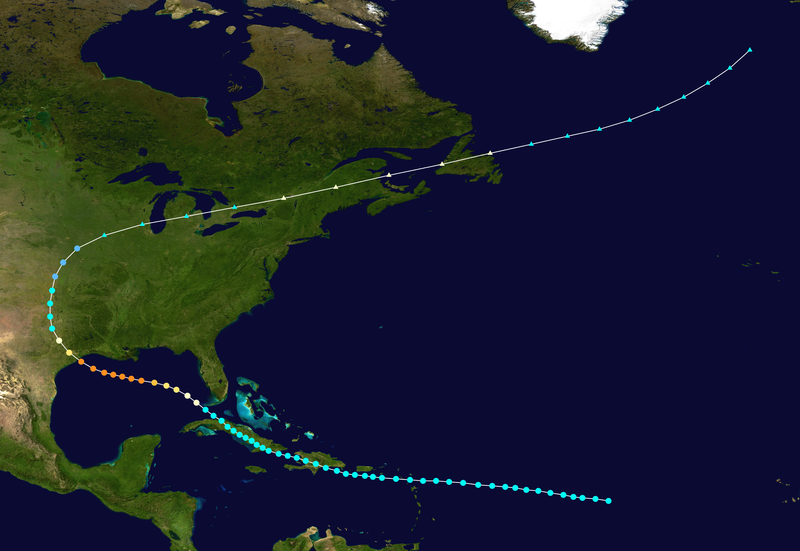
Every time I see an update on TS Isaac, I think of "Isaac's Storm"*, the Galveston Hurricane of 1900 that killed an estimated 6,000 to 12,000 people, (generally 8,000 officially accepted), the most of any hurricane to make landfall on the continental U.S. That hurricane, which occurred before the current system of naming hurricanes, made landfall on September 8th so we're not looking for any interesting coincidences.
At the moment TS Isaac is following a similar path to the 1900 hurricane but is forecasted to turn north and possibly make landfall around the Florida panhandle instead of charging straight through the Gulf toward Texas.
I'll be keeping an eye on Isaac. If landfall is made too far to the east, we won't even get any rain out of it. Some of the people who really need the rain (i.e. Georgia) will get it, but others (the central states) probably won't be affected in the least.
*Named after the resident meteorologist, Isaac Cline. See the book of the same name.
The northern Gulf of Mexico has been a ho-hum-ish place this summer but it's still very early in the season and things are bound to start getting more interesting. The activity has primarily involved Florida up through South Carolina.
T.S. Ernesto, heading through the eastern Caribbean initially looked promising for a situation that would affect my area personally (S. MS) but has taken a southern turn and will probably affect the Yucatan peninsula instead. Of course, model predictions are only as good as the information they're fed and are not infallible in any case, so we'll just keep an eye on it. Even if it restricts itself to the southernmost parts of the Gulf it will affect the surf in the rest of the Gulf so people living on the coast will notice a difference.
T.S. Florence is way out there in the eastern Atlantic but is a more organized storm than Ernesto at the moment. It looks like it probably won't even make it into the Gulf but head up the Eastern Seaboard instead. so will be slightly less interesting from my personal point of view.
A brief look at the summer season so far (since I've been such a lazy bum):
T.S. Alberto: [May 19-22] Formed off the SE coast of TX and stayed offshore. 23rd pre-June named Atlantic Basin storm on record since 1851. Other than some rain, little impact on land.
T.S. Beryl: [May 25-30] Ruined Memorial Day weekend for many on the SE US coast. Wandered around before finally making landfall as the strongest tropical storm to hit the US mainland before June 1st. Several inches of rain, wind and downed trees (and powerlines) were the result of its march through Georgia and South Carolina before it surrendered.
Hurricane Chris: [June 19-22] (from the Weather Channel:) "While Chris was no threat to land, it became the 2012 Atlantic season's first hurricane on June 21, at a latitude of roughly 41 degrees north, no less! Only one other time on record during the month of June was an Atlantic hurricane farther north than Chris. You'd have to go all the way back to 1893, when a hurricane in post-analysis made it as far as 44 degrees north latitude, just south of the coast of Newfoundland! Only twice before in history (1887 and 1959) has the third storm of the season formed earlier than Chris." Chris never impacted land but made a semi-circle in the North Atlantic.
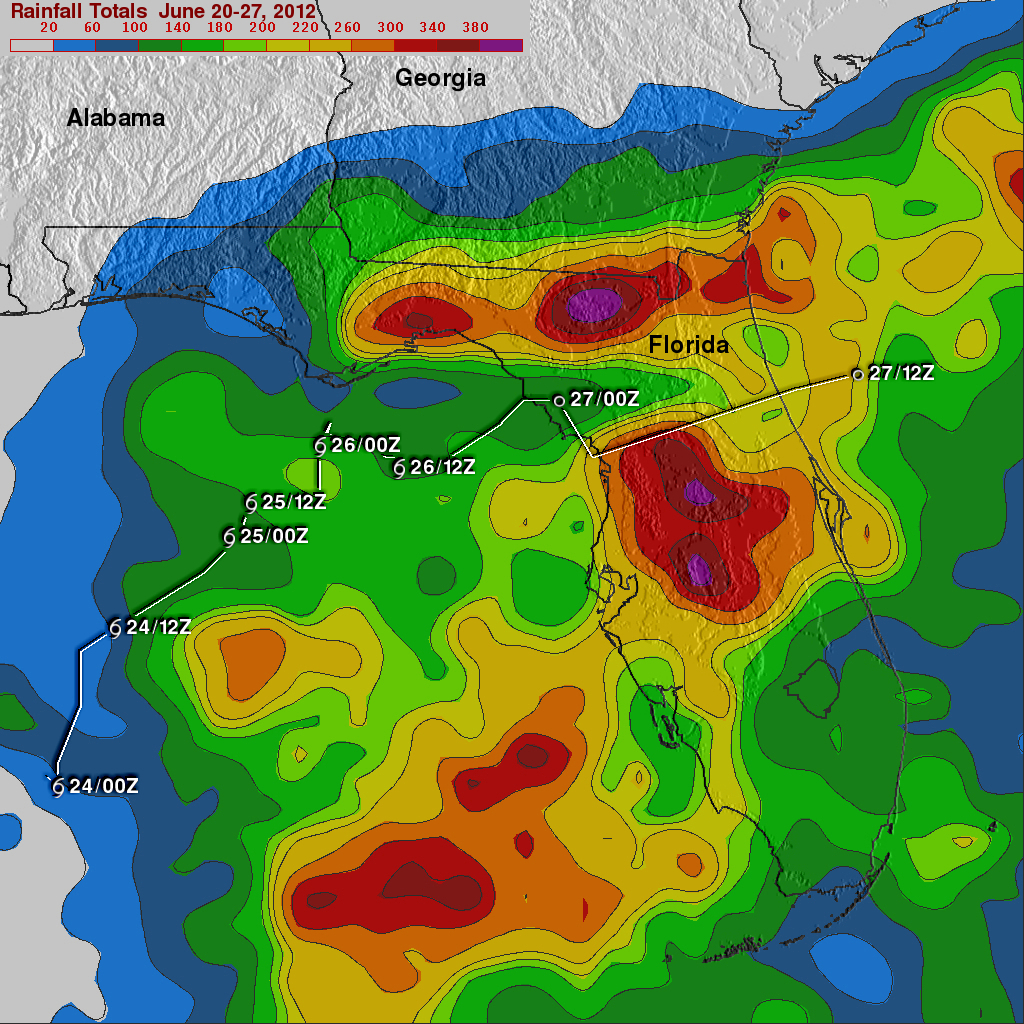
T.S. Debby: [June 23-27] The average date for the formation of the season's 4th named storm is August 23rd. Note that we're already on our sixth named storm and it's only August 5th! Debbie was primarily a rain event which sounds rather boring until you realize that it was a LOT of rain. Look at the NASA map below to see some of the cumulative rainfall amounts. The most was an unofficial report of 28 inches in Wakulla County, FL.
There were also 21 tornadoes associated with Debby, with one fatality reported from an EF2.
I found this heat index chart online. For people who live elsewhere
than in the more hot and humid areas of the U.S., it can be hard to
convey just how awful the day is going to be when the humidity is 88%
and the temperature is 82F at 7:30 in the morning.
For
the past month (July) our average dew point was 72 degrees. The high
was 79 and the low was 60. The low dew point seems to have occurred on
two different days at the beginning of the month, but other than those
two days, the dew point did not dip below 70.
I
think this is just one of those worthwhile things to know and understand
so I'm going to brave the crickets chirping in the deadly silence after
this post and go ahead and do a public service announcement. Stick with
me if you can.
From Wikipedia:
The dew point
is the temperature below which the water vapor in a volume of humid air
at a constant barometric pressure will condense into liquid water.
Condensed water is called dew when it forms on a solid surface.
The
dew point is a water-to-air saturation temperature. The dew point is
associated with relative humidity. A high relative humidity
indicates that the dew point is closer to the current air temperature.
Relative humidity of 100% indicates the dew point is equal to the
current temperature and that the air is maximally saturated with water.
When the dew point remains constant and temperature increases, relative
humidity decreases.
Everyone knows what dew is:
when you run out to get the paper in the morning and the grass is all
wet, that's dew. When there's enough water in the air and the
temperature gets just low enough, it forms. Obviously, if the
temperature at which it will form (the dew point) is high, that means
two things: it's pretty darn hot and it's pretty darn humid. Numbers are
just abstract things though, so I provided the nifty chart above.
"So
what?" you may be thinking. "It's the heat that will get to you,
right?" Well, yes, heat certainly plays a part, but what cools you off
in the heat? Evaporation. Water vapor has more energy than liquid
water. As sweat evaporates, in other words, turns from a liquid into a
gas, it absorbs heat and you feel cooler. You feel the opposite when you
stick your hand over some steam. As the water vapor condenses back into
liquid water on your hand it releases heat and you get a steam burn.
The drier the air is (the lower the humidity) the more "room" there is
for water to evaporate. If you stick a bone-dry sponge near some water
it will suck it up immediately. So when the air is dry sweat evaporates
quickly and you lose the heat to evaporation.
But what if it's humid? Humidity is
like measuring the amount of water already in the sponge. The more
water the sponge contains, the less water it can absorb. Saturation
occurs when the sponge can't absorb one more drop of water. If you stick
a saturated sponge in a puddle of water, the two just sit there.
There's no more room in the sponge for any of the water. The weather men
on TV don't just talk about humidity though - they talk about relative humidity.
Remember when I said that humidity is like measuring the water in the
sponge? Well, one thing you have to know is that the warmer the sponge,
the more water it can absorb. (This metaphor starts to break down a bit
here because that doesn't actually happen with the sponge...I think.) So
the warmer the air, the more water vapor it can hold.
The
practical application to this is watching what happens when you are
outside on a hot day with high dew points. You exercise, your body
sweats to try to cool you off...and the sweat just sits there. You find
yourself wiping it out of your eyes, your clothes are wet, etc. The air
simply can't hold any more water. You can't cool off because you can't
use evaporation to remove heat from your body. One thing that helps
evaporation is wind so if it's a breezy day you will lose a little more
heat than you would have without it. Otherwise, you're going to feel
pretty icky.
All that is just to say that I can't wait
for fall because these morning and evening walks with dew points of 79
and 80 are not fun.
Just got a new book in the mail: Great British Weather Disasters. Most of my books cover American storms and such (except for one Canadian and some general books) so it will be nice to read this one. Plus, it's wonderful to have a new book no matter what!
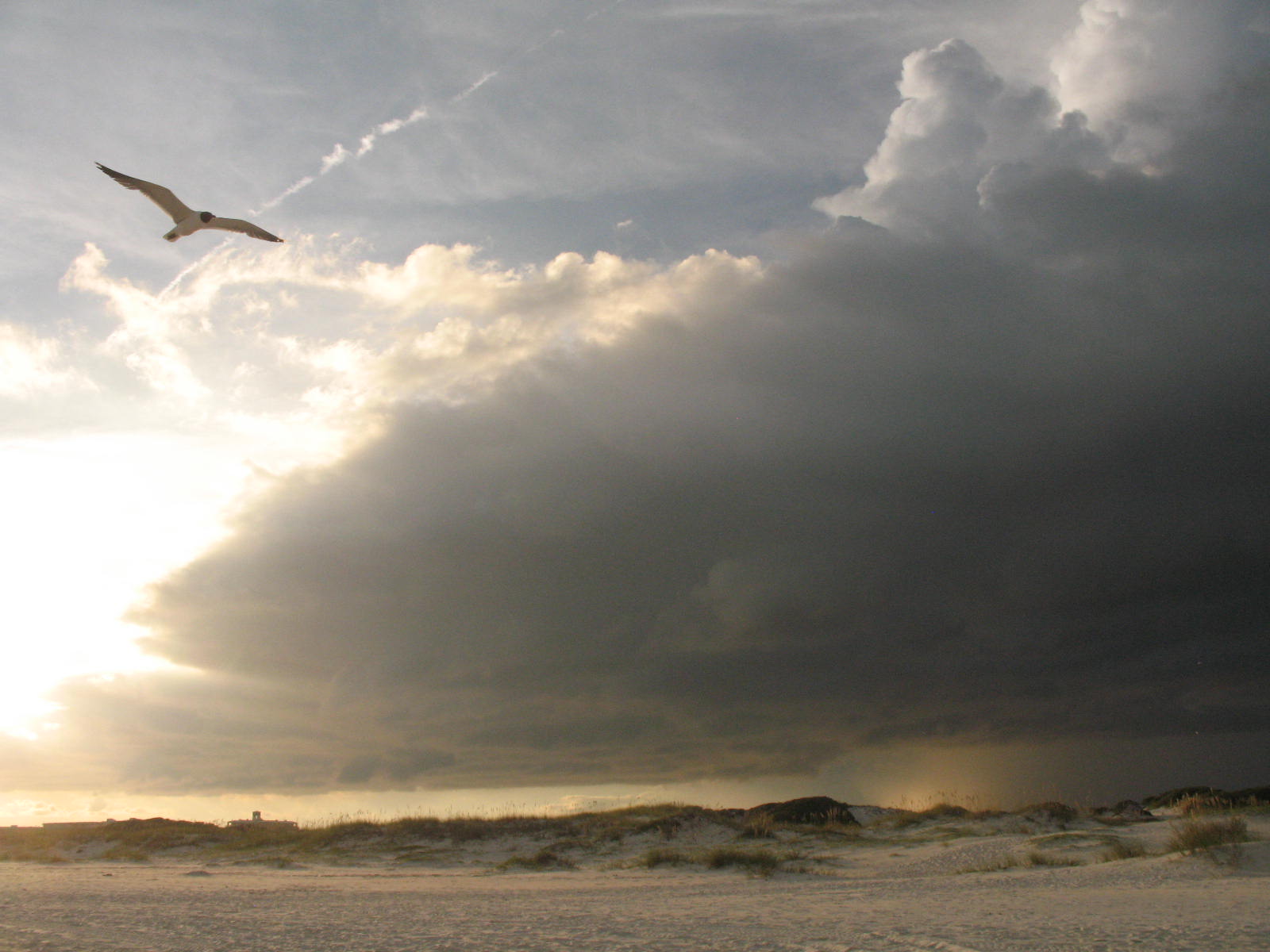
Some storms in the area but they are very persistently avoiding our house. The sunset was quite lovely though, despite the poor situation of the house.