Thursday, August 30, 2012

Local Aftermath

We seem to be among the very lucky people because we only lost power for a few hours last night, still have power, water and internet...and an intact roof. The other side of our street doesn't have power and indeed, most of our town doesn't have power. In fact, I can hear the generator running at the ATT building on the opposite corner of our block. Our house is fine; we mostly have small debris covering everything. The church and hall are fine except for the same small debris. I went out to see what was going on (which you're not supposed to do) and took some pictures. I did pass one house partly smashed by a large tree, but I didn't take a picture; it seemed heartless.

This is at the end of our street, a block and a house away. 


Looking through the blocked intersection.


Another view. You can see it came down right across the power lines.


Three blocks from our house.


About ten blocks from our house.


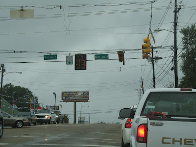
About five blocks away on the main road. The signals are out.


And in one case...missing.


About eight blocks from our house in another direction.


About four blocks away.


And, a little closer to home, the zinnias survived.


And we wound up with just a light covering of small debris.


Interestingly, I found this graphic:


Our little town has achieved notoriety. Also, it explains why the dam at Percy Quin State Park is full and about to go. They are evacuating 50,000 people below the dam in Tangipahoa Parish, LA. Let's hope it holds.

map-percyquindam-083012.jpg

Watch Isaac Pass

It's neat to look at our local stats for the week and see Isaac pass. Of note: The humidity was very high (duh!) so you see the temperature and dewpoint right up next to each other. Notice that the temperature remained fairly constant once the heavy cloud cover and rain started. Looking at the pressure you can see that just after midnight the center of the storm passed. Even though I don't exactly remember it, apparently we had gusts to just over 40 mph but our steady winds never really got out of the 20's. MUCH lower than forecasted. Also interesting, you can see the wind direction changing from the north to the east and now to the south as the storm passed by.


Wednesday, August 29, 2012

Videos of the storm

Frankly it has been a rather boring day. It has rained, more or less continuously, and we've officially had just under 2 1/2 inches of rain. The wind started out just a bit squally but graaaaadually increased to gusts of 20-30 mph. We haven't lost power and the weather has generally not lived up to the forecast, but then it rarely does. Isaac, now back to a tropical storm, is nowhere near gone though: It was moving at about 7 mph this morning and now it's moving about 5 mph to the NW. We've got a loooong way to go. In fact, Pickles remarked on how long the storm was lasting while I was out on the porch taking a video of the winds. As usual, a child steals the show.


Wednesday

I woke up this morning to squally conditions but nothing impressive. Isaac is still moseying along at 6 mph. It's basically going to keep raining for the next 24 hours or so.

The cat, who is well on his way to being named Isaac, is still with us. He's chasing a moth in the window of the porch as I type. I think he spent the night under the house.

I'll update as soon as there's anything worth updating. Ho hum.

Tuesday, August 28, 2012

(Finally!) "Hurricane" Isaac [With updates]

Well, it's about time! I missed the advisory 30 minutes ago (wasn't expecting it and you have to clean the kitchen sometime) so my sister had the joy of texting me to tell me that Isaac had finally attained hurricane status.

It's gotten rather pretty too... (But notice the blurb at the top left still says "tropical storm")


Tuesday afternoon (28th): The last update showed steady winds of 80 mph with gusts to 95 mph so there is some slow strengthening going on. I'm not sure how much stronger it will get before interaction with the coast starts bleeding out the energy. We've had one rain band go through, not much more impressive than a garden-variety rain shower. At the moment the sky is streaked with clouds with plenty of blue sky showing. The next band looks bigger and stronger but it's still a ways off. Because we're between bands, the breeze is light, there's the lack of rain and the bits of blue sky, and all in all it makes one feel foolish about cancelling Vespers. However, several hours ago we really didn't know what conditions would be and it seemed better to be safe than sorry.


Always like watching this...

Isaac *still* a tropical storm


Tuesday morning (28th): I got up this morning and the first thing I did was check the weather. The much anticipated strengthening of Isaac to hurricane status did NOT happen overnight as was expected. It's still right on the edge with winds of 70 mph and gusts to 85 mph. The forward speed has also slowed to 7 mph. As landfall is supposed to happen overnight tonight it has one more day to pull its act together and tighten up an eye. For once, the computer models are all in agreement about landfall which should happen around the toe of LA. It looks like landfall will be after midnight, putting it on the 29th and the 7th anniversary of Katrina. I'm sure there will not be fireworks in the streets of New Orleans.

Visible Satellite
Is it opening its eye??

This morning it's a little breezy with winds out of the NE. There are some upper-level clouds advancing out of the SE, precursors of the rain bands to come later today. Interestingly, the vast majority of the thunderstorm activity seems to be on the S and SW sides of Isaac, quite unusual. Usually you would have very heavy bands raking the coast to the E and NE of the center. I'm not sure if this will change as it moves ashore.

The slow movement is the worrisome thing here:

Heavy Rain Threat

We're not in a low area, near a river, etc. I think we can expect our back yard to turn into a lake though.

Monday, August 27, 2012

Cirrocumulus Clouds in Advance of Isaac


Waiting for Isaac [with updates]

Monday morning (27th): Isaac is still trudging NW but hasn't had any significant strengthening supporting the probability that it will only attain cat. one status before landfall. Earlier, based on the 5 AM advisory I was thinking landfall may be closer to Tuesday afternoon but after seeing the 11 AM advisory it looks more like Tuesday evening. They also (although they have not specifically stated this) seem to think the forward motion will slow down significantly once landfall is made. That will create a little more hazard from the prolonged rain. It's a beautifully clear, sunny day right now although some advance cirrostratus can be seen. More cloud cover should be in place by evening. There is a very, very light breeze out of the NNE.


I've found one webcam on the AL beaches that is (sometimes) working. LINK


If no image is displayed, the maximum number of clients may already be connected.

Monday Evening (27th): The last advisory changed the forecast again, upping the estimate to a cat. 2 at landfall. The outer rain bands are already coming across the toe of Louisiana and you can see a nice upward curve in windspeed on the offshore buoys. Here it's merely a nice (warm) summer evening with just a little breeze here and there.

A young cat has made itself at home with us. It has a flea collar on and is obviously domesticated and in good health. However, we already have two adult cats who were less than impressed with this little interloper. I'm sure it lives at the house on the corner where I've seen several cats in the past. It needs to go on home before tomorrow before the weather gets bad. We're not taking any of our own cats in and we certainly aren't taking in someone else's. Our cats will be perfectly happy under the house as usual. Since the children have played with and petted the cat all day it is in no hurry to leave. Sigh.

Saturday, August 25, 2012

Edging West...[with updates]


Saturday Evening (25th): TS Isaac computer models have slid a bit west of earlier predictions. Now it looks much more like we'll be affected personally (and that the beach house will be fine) but it's still to early to tell.

I hope people will forgive me if I do a little happy dance now. (:


Sunday Update (26th): Models still look like the one from last night. Isaac should make landfall in the Keys this evening and then the big question remains: where will he go?? It all depends on the trough to the north. If it gets ahead of it (looking less likely) then it makes a fairly sharp curve to the north and east. If it gets stuck behind it...it heads much farther west. If it makes landfall around MS/LA on the 29th (Wednesday) then it will be hitting in about the same place seven years to the day after Hurricane Katrina. Amazing. At least it shouldn't be a cat. 4/5. At the moment, the west panhandle of Florida, Alabama, Mississippi and southeastern Louisiana are under a hurricane watch.


Sunday Evening Update (26th): Despite greater organization in the eyewall, TS Isaac has not intensified yet. Considering it will be over the bathwater in the Gulf shortly I think we can assume it will be a hurricane soon. Models have continued to stay in the general area indicated in the map above. I went out to get some necessities (water, tp, charcoal, lighter fluid, canned fruit, etc., etc.) and noticed that the town appears to be completely out of jug water. Bottled water is still available but is going fast. I got two cases of bottled water. I'm going to fill a lot of clean plastic containers with water and freeze them and fill a lot of clean glass jars I've saved and put those in the fridge. If things look impressive on Tuesday afternoon I'll make sure everyone is clean then fill the bathtub. The lady checking me out said that last time (i.e. Katrina) they filled their bathtub too - also a clawfoot - and ran out. She said that people were buying large trash cans to fill with water. Not a bad idea come to think of it. I do think that the rush to empty the store shelves (there was NO bread) and stock up on water is an indication of how much people here suffered during Katrina in 2005. Many places around here had no power for 3 weeks and no water for most of that. Isaac is almost certainly not going to be another Katrina so I think we'll be in good shape.